Before the development of the Interstate Highway System (IHS), intercity and cross-state travel in the United States relied on a network that encompassed city streets and peripheral county roads.
In San Antonio, Texas, the main routes for traffic in the commercial outskirts of the city consisted of parallel roads without any direct connection. By the 1930s and early 40s, San Antonio faced growing traffic congestion and the government initiated the construction of expressways to divert through traffic away from the downtown area. Nevertheless, as San Antonio’s growth persists, the ongoing increase in traffic demands a comprehensive exploration of alternative and contemporary transportation solutions, prioritizing innovation and adaptability. To address congestion along two large arterials, the City of San Antonio contracted KCI to create a model that would benefit drivers and pedestrians throughout the area.
At the intersection of Austin Highway and Eisenhauer Road along Harry Wurzbach Road, drivers encountered disjointed access, often necessitating detours through nearby business parking lots to navigate the area. This posed a danger to pedestrians and cyclists that frequented the adjacent businesses and shared the road to access these shops. The absence of sidewalks or designated paths resulted in bikes being ridden on highway shoulders or in vehicular lanes, and dirt paths being organically created through the grass. Additionally, pedestrians and cyclists struggled to cross safely through the intersection due to the lack of crosswalk buttons or designated safe crossing times.
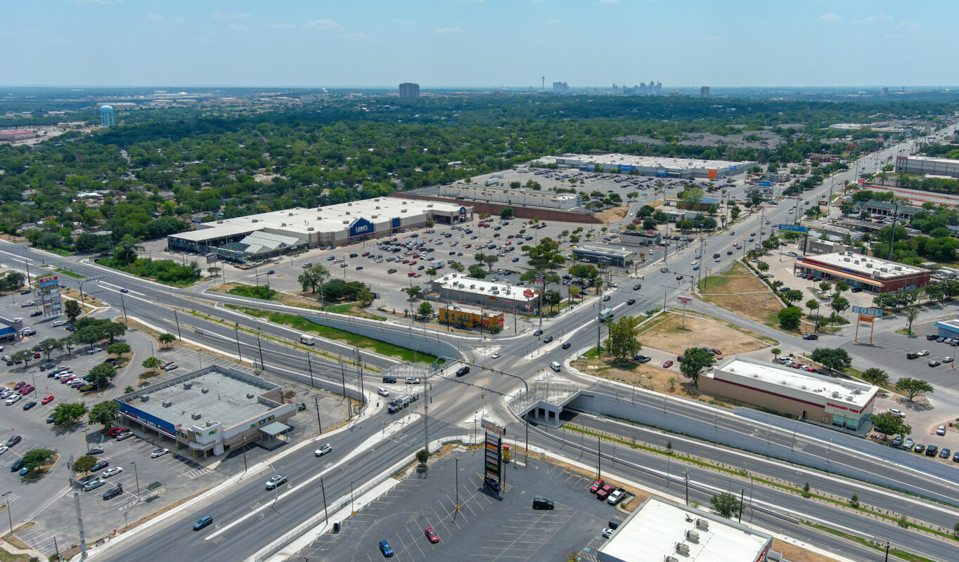 With drivers cutting through private property to navigate the area, businesses and their patrons were at an increased level of risk.
Initially, a high-level concept for the connection had been developed that involved a separated grade intersection at Eisenhauer Road with ramps connected to Austin Highway. While this solution would have reduced delays along Harry Wurzbach, the design’s addition of two signalized intersections in a split diamond configuration would lead to traffic increases at Eisenhauer and Austin Highway. In typical diamond interchange designs, the paths of left-turning traffic cross each other in the center of the intersection. With stoplights on either end, it can often take several traffic signal cycles for a vehicle to complete a turn and clear the roadway. To improve on this solution, the City of San Antonio engaged KCI to design an alternative plan aimed at alleviating congestion and enhancing safety for both drivers and pedestrians.
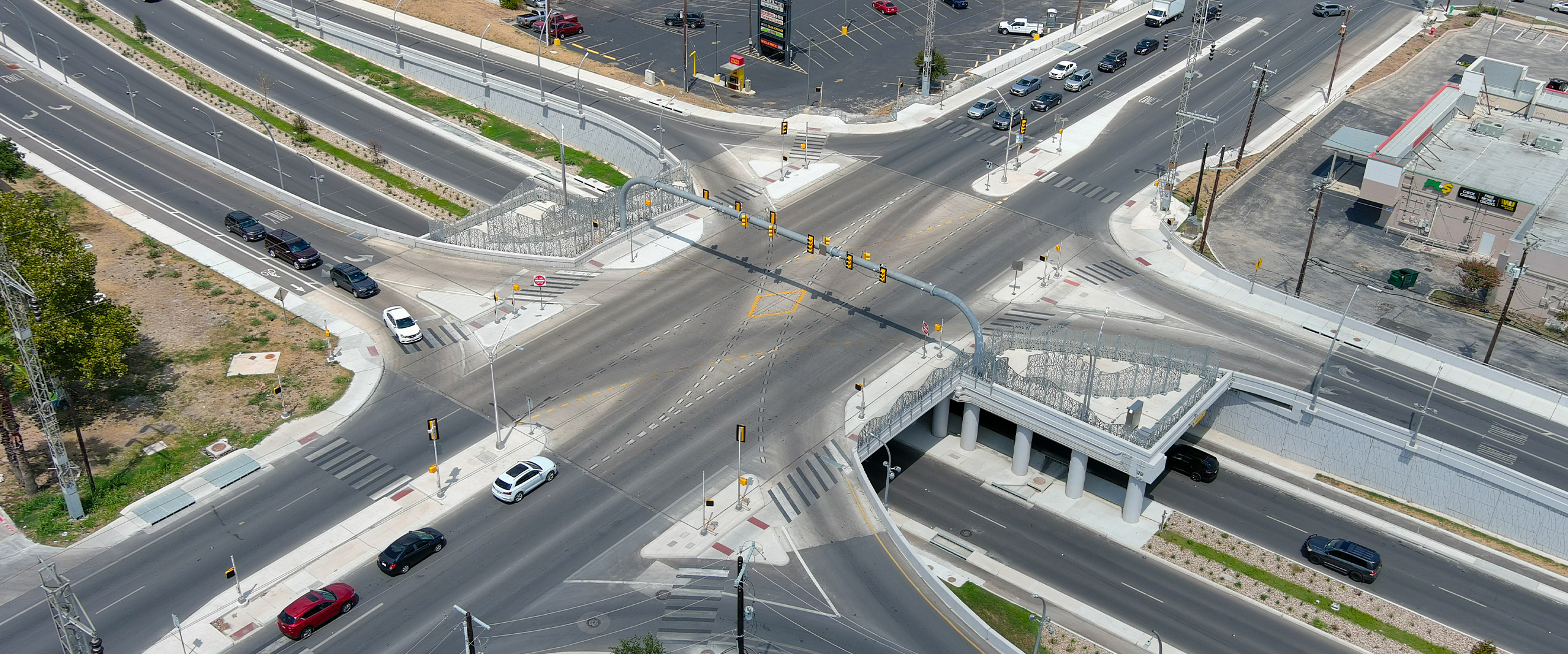
To address the challenges at hand, our team’s design concept incorporated four ramps connecting Harry Wurzbach and Austin Highway, controlled by a single-point urban interchange (SPUI). Recognized for their efficacy in managing intricate traffic patterns within limited space while minimizing impacts on surrounding development, SPUIs offer a unique solution. In this configuration, all ramps converge at a single point beneath or above the highway, thereby streamlining traffic movements. The unified operation under a single set of traffic signals allows left-turning cars to enter the intersection at the same time with no conflicting movements, enabling vehicles to proceed through the area in one stoplight cycle and helping to enhance efficiency.
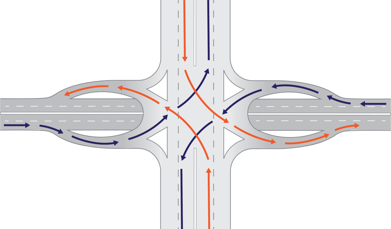
A SPUI also presents the advantage of accommodating more traffic within a smaller footprint compared to a conventional intersection. Unlike the expansive land requirements of a cloverleaf traffic design, the compact nature of a single-point design allows for the construction of new interchanges within existing public Right of Way. This not only optimizes land use but also proves advantageous for the seamless navigation of large vehicles such as buses and trucks, thanks to the wider turn angles in a SPUI design. Given the diverse array of features along the corridor, ranging from retail stores to the Fort Sam Houston Army Base, it was necessary to create a crossing that catered to the needs of various multimodal travelers to pass through without causing delays.
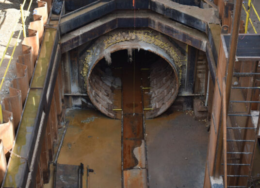
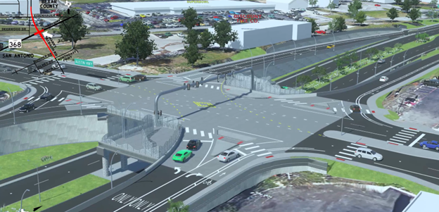
Throughout the design phase, KCI collaborated extensively with local advisory committees to prioritize the safety of cyclists and people traversing the intersection. Our team performed a static LiDAR scan to confirm the accuracy of a previous as built bridge survey and decrease the amount of total time surveyors spent in the field. Following the survey phase, engineers were able to address concerns for pedestrians and cyclists by adding bike lanes and walkways to the design that consisted of sidewalks, curbs, medians, crosswalks, protected bike paths, bike signals, and signage coupled with rapid flashing beacons to increase driver awareness at crossings.
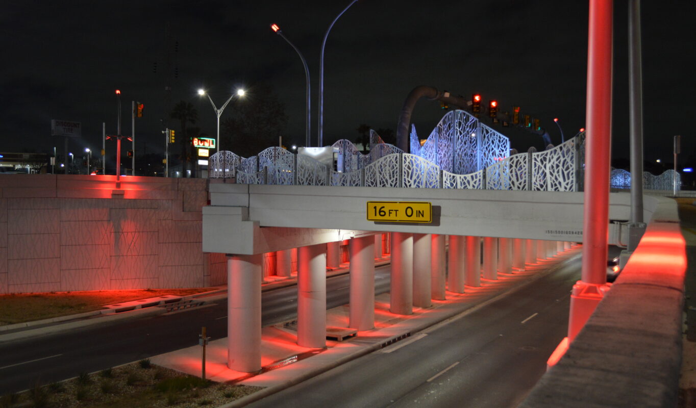
At the Eisenhauer Road intersection, a signal specifically for bicycles was incorporated into the plan. This feature allows riders to press a button, requesting a red light for highway traffic and enabling conflict-free crossing. Special crosswalks with flashing lighted signs, called Z-crossings, were designed to alert drivers of pedestrians in the area. In addition, retaining walls along the elevated roadway, were created with an emphasis on visual enhancement. Rather than installing a simple chain link fence to prevent pedestrian falls from the bridge structure, engineers developed unique lighted panels and surrounded the interchange with extensive landscaping to improve both welfare and aesthetics simultaneously.
To secure support from local businesses and the community, our team conducted extensive outreach efforts throughout design and construction. While single-point urban interchanges are fairly common across the U.S., they are a rarity in Texas. KCI took proactive measures by organizing numerous public meetings to keep the community well informed about the ongoing changes.
Working to visually communicate the design’s intricacies and innovative solutions, our team crafted 3D project models for the intersection. These models not only showcased the project’s features but also served as effective tools during community engagement. Leveraging the initial LiDAR scan details, conceptual renderings were developed with the help of KCI traffic modelers. This ensured not only the accuracy of the project’s infrastructure representation in model videos, but also the correct portrayal of traffic patterns. The outreach efforts played a crucial role in garnering local business support, assuring companies that their customers would maintain easy access to their facilities.
 The addition of designated crosswalks enabled cyclists and pedestrians to cross the highway safely for the first time in the region’s history.
As the final design met community needs and fulfilled requirements, our team successfully navigated the conditions associated with construction funding from various sources. Prior to the start of interchange construction, the contractors leveraged the data obtained from the LiDAR scan to streamline their planning processes for the construction phase.
After the interchange was successfully completed and opened to the public, KCI monitored the flow of transportation, adjusted signal timings, and directed traffic as needed. A hands-on approach was critical to ensure the seamless operation of the infrastructure and maintain optimal safety standards. After observing instances where further guidance for drivers could be enhanced, our team implemented supplementary signage and pavement markings while monitoring the site and looking for additional opportunities for improvement.
 Combining both operational and aesthetic improvements, the new interchange allows drivers, cyclists and pedestrians to safely cross without waiting for multiple stoplight cycles.
As this intersection marked the completion of the first SPUI in San Antonio, its impact on the transportation landscape is transformative. The innovative design, featuring an elevated interchange and synchronized green lights for left-turning vehicles, has redefined how drivers, pedestrians, and cyclists navigate the bustling San Antonio region, particularly in accessing Austin Highway and the surrounding infrastructure. The success of this project, evident in its ability to facilitate safe and efficient flow for all modes of travel serves as an example for the future of transportation in the region. Given its successful implementation, the Harry Wurzbach intersection may be the first of many SPUIs to shape the evolving transportation landscape in San Antonio.