
By Marco Menendez, PE
Practice Leader
Water/Wastewater
Additional Contributors
Kristin Johnston, GISP
Carl Whitlow
The Lead and Copper Rule Revisions (LCRR) and Lead and Copper Rule Improvements (LCRI) introduce major changes to how drinking water systems are managed and monitored.
These updates place greater emphasis on early planning, strong data organization, and coordinated technical efforts. As utilities and municipalities work to meet these new requirements, there are several key principles and best practices that can support long-term compliance.
Service Line Inventory as the Foundation of Compliance
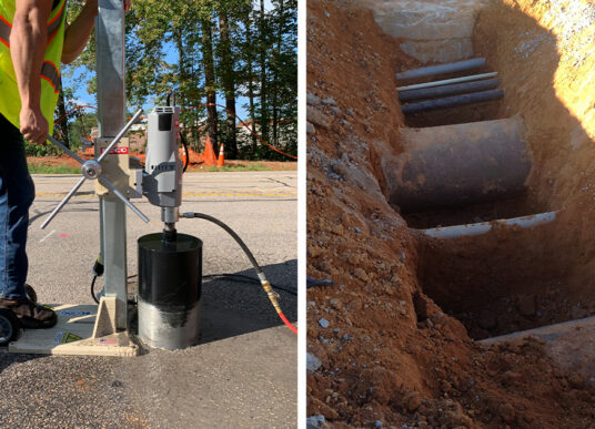
Under the updated LCRR regulations, every water system must complete a system-wide Lead Service Line (LSL) Inventory. This inventory requires each service line to be classified as lead, galvanized requiring replacement (GRR), non-lead, or unknown. Each classification must be supported by records or physical verification. The inventory must also be updated regularly, either annually or every three years depending on monitoring schedules, making accurate data management essential.
Geographic Information Systems (GIS) have become one of the most effective tools for tracking and organizing this information. GIS helps teams understand how their systems are connected, plan field investigations, and clearly share information with the public. When used effectively, GIS can also support smarter decisions about where to sample, excavate, and focus replacement efforts.
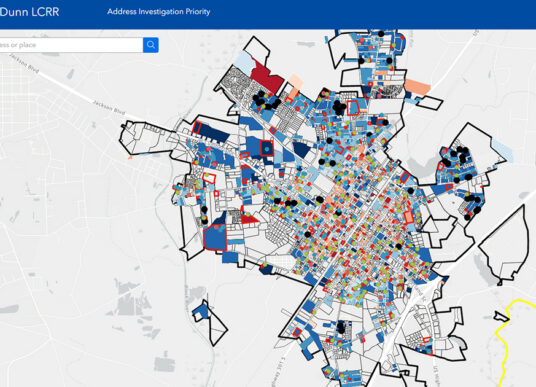
For example, KCI completed a full water service line inventory for the City of Dunn, North Carolina. The project included custom GIS data layers that supported accurate field data collection and were compiled into a standardized geodatabase. This gave the City a reliable, well-organized dataset to support reporting, transparency, and long-term planning under the new regulations.
Stricter Action Levels and Communication Preparation
One of the most significant changes under LCRI is the reduction of the lead Action Level from 15 parts per billion (PPB) to 10 PPB. With this lower threshold, more utilities may trigger required actions such as public notifications, corrosion control reviews, and faster replacement schedules.
To stay ahead of potential issues, utilities should prepare response and communication plans in advance. Having notification templates, clear workflows, and public-facing GIS maps ready can help reduce confusion and strengthen public trust when elevated results occur.
Lead Service Planning Has Become Mandatory
Utilities with known lead, suspected lead, or GRR service lines must now develop a Lead Service Line Replacement (LSLR) Plan. This plan must outline ownership responsibilities, replacement strategies, and customer notification procedures.
Using predictive modeling alongside field verification can help reduce costs and improve efficiency, especially when identifying unknown service lines. Modeling allows utilities to focus excavation efforts in the most likely locations, limiting the need for widespread potholing across the entire system.
Effective Communication Is Imperative
The updated rules place a strong focus on transparency and public engagement. Utilities are now required to provide public access to service line inventories, promptly share sampling results, offer educational materials when exceedances occur, and clearly explain the difference between sampling results and confirmed contamination.
Once again, GIS can support these efforts by presenting data through easy-to-understand public maps that help prevent miscommunication and improve community understanding.
Successful Compliance Requires Interdisciplinary Expertise
Meeting LCRR and LCRI requirements is not a single-discipline effort. Utilities looking to modernize their systems will benefit from integrating GIS and asset management tools for better mapping, tracking, and analysis. They can also draw on expertise in subsurface utility engineering (SUE), water treatment, and sampling to ensure all regulatory requirements are met accurately and efficiently.
A coordinated, multi-disciplinary approach is quickly becoming best practice across municipalities. KCI supports every stage of the LCRR/LCRI process, providing GIS, SUE, sampling, engineering, and treatment services as a streamlined, one-stop solution. This reduces coordination challenges and helps utilities move efficiently from inventory development to long-term compliance. To learn more, contact us.