The city of Baltimore maintains an extensive network of water and wastewater infrastructure serving its residents and businesses.
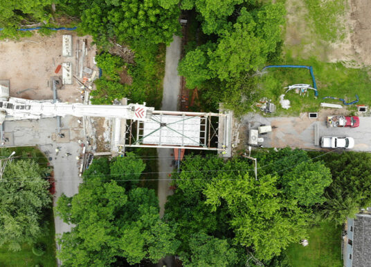
The Department of Public Works was working with a contractor to address a broken pipe that was leaking sewage directly below Baltimore’s Light Rail line and into the Howard Street rail tunnel below which carries freight trains operated by CSX. To avoid disrupting the light rail service and disturbing the physical MTA light rail track bed, the contractor proposed accessing the wastewater line by digging a vertical access shaft in the street and tunneling in a horizontal direction over to repair the damaged section of sewer pipe. KCI was contracted to monitor both the Howard Street CSX tunnel ceiling below and the MTA light rail tracks and platform above the excavation for any movement or impact from the construction work.
The two rail lines are owned by different organizations. The Maryland Transit Administration operates Baltimore’s surface-based Central Light Rail Line. The tunnel and tracks below are maintained by CSX. Each organization had different requirements for frequency of monitoring.
The Light Rail tracks were monitored using traditional surveying methods utilizing a matrix of survey control points on the trackbed and platform. The CSX line posed more significant challenges in terms of access and data requirements. Built entirely of brick in the 1890s and extended nearly a century later, the Howard Street Tunnel serves as a critical north-south linkage for freight traffic through the city. CSX dictated when survey teams could access the Howard Street tunnel and designated our “working” timeframe in the tunnel to minimize any disturbance of freight traffic. Crews had approximately a 35-minute window to work in the tunnel for each mobilization.
“We had to be innovative in coming up with an approach that would allow us to obtain the necessary data within the set time constraints.”
– Colton Cilento, PLS, Senior Project Surveyor
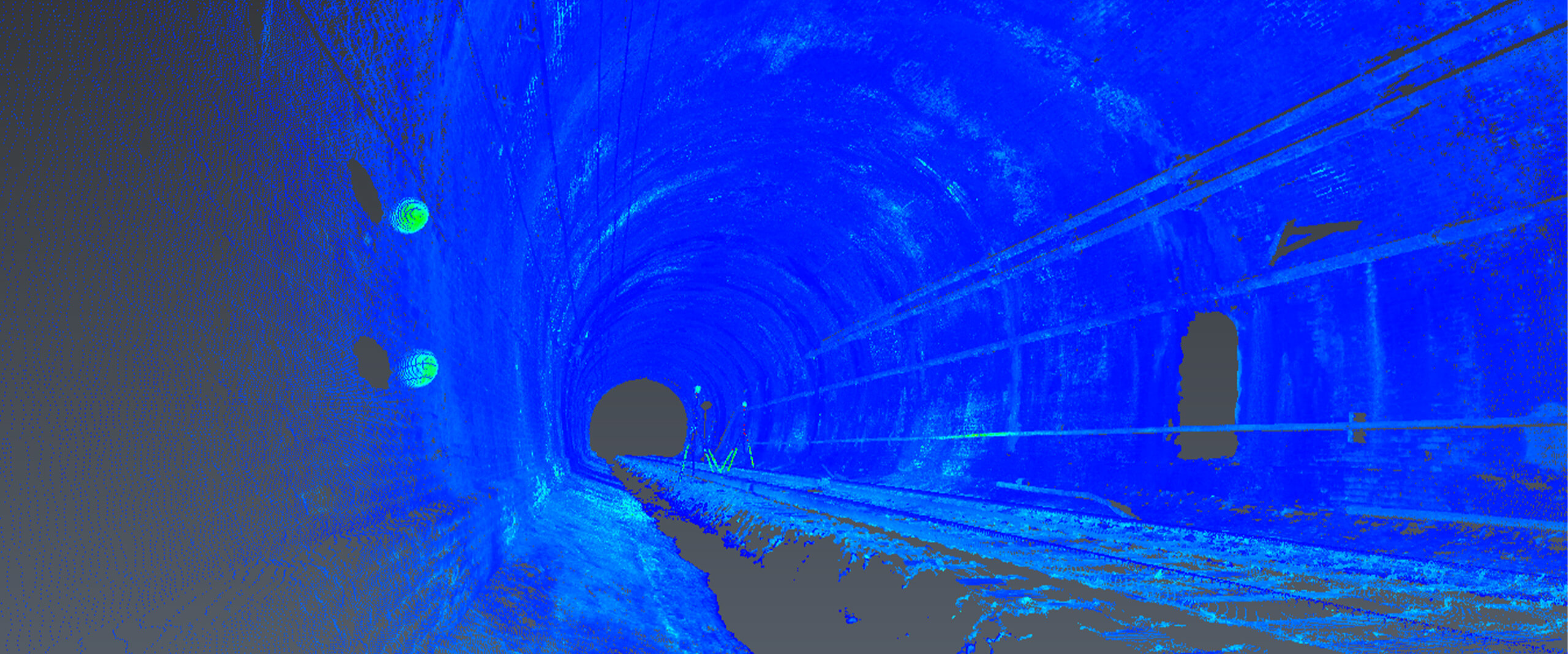
Initially, surveyors were requested by the client to complete a daily monitoring survey using a stationary robotic instrument that would be permanently mounted inside the tunnel to record prism targets. In order to get adequate data, 100 prisms would need to be individually attached to the tunnel ceiling to create a matrix across the arch. Each mounting would require a threaded steel rod to be drilled into the brick. To record the survey data, a CAT5 telecommunications cable would have to be run thousands of feet between the stationary robotic total station and a data transmission device at the tunnel entrance. Because mounting prisms across the arch would require a scissor lift to access the tunnel ceiling, our survey team recognized early on that creating the matrix of 100 control points needed to accurately monitor the tunnel was not a feasible solution. The allotted time window provided by CSX for tunnel access of just 35 minutes each day was inadequate for the prism installation. Instead, KCI proposed laser scanning as an alternative. Surveyors worked with the contractor and CSX personnel to install just six globe targets on the walls at chest height, eliminating the need for a scissor lift. Each globe target required only 15 minutes for installation. This also avoided any potential structural compromise to the brick arch that the ceiling-mounted target matrix posed.
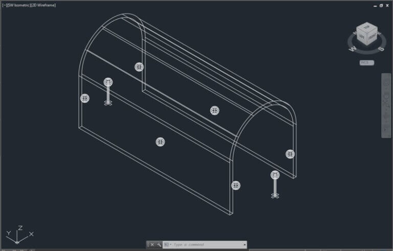
The target globes, which are strategically positioned in the tunnel, help define coordinate references inside
A benchmark laser scan was performed to create a 3D point cloud of the tunnel prior to the start of the sewer repair excavation above. Once construction began, survey crews completed an initial laser scan and 3D Reshaper software was utilized to create a heat map that indicated any movement to the tunnel structure. The scan provided additional data with increased accuracy over a larger area versus what the initial conventional surveying data would have provided. Instead of a 1-foot grid of prisms covering 50 linear feet of tunnel, the point cloud offered a 1-inch matrix covering 400 linear feet of tunnel. The scan data was able to confirm that excavation above the tunnel was not causing any movement to the tunnel structure, and CSX reduced the frequency of scans from weekly to monthly throughout the six-month construction duration due to their confidence in the survey methods.
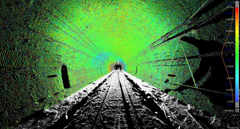
Heat maps were created to show any movement between the weekly scans and the original benchmark scan.
Separately from the tunnel scanning, the contractor asked KCI to map the street side access tunnel after encountering an unknown conduit in the horizontal tunnel. Survey crews were able to lower the LiDAR unit into the 15-foot deep vertical shaft and scan into the horizontal tunnel. This laser scanning process was necessary to avoid specialized confined space issues associated with the horizontal access tunnel. Traditional survey traverse was established nearly one mile down the street from the sewer construction excavation area and into the CSX tunnel, allowing survey technicians to register both point clouds together and give a true-to-life model of the physical separation between the street excavation and the CSX tunnel. With this information in hand, the CSX team was able to determine that the approach proposed by the contractor, switching to a 45 degree down portion of horizontal access tunnel, could compromise the 12 layers of brick on the topside of the CSX tunnel. Therefore, another solution had to be found. The contractor’s ultimate solution was forming a modified liner plate design to stabilize the horizontal access tunnel with a flat top supporting the unknown conduit, thereby avoiding any conflict with the Howard Street CSX tunnel below.
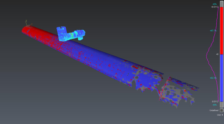
Obtaining a LiDAR scan of the horizontal tunnel allowed the contractor to visualize otherwise unforeseen and costly issues and prompted the need for a new solution.
Due to KCI’s innovative approach, CSX experienced no disruption to service throughout the sewer repair schedule. The approach taken brought together Land Surveying staff from 3 states and 4 offices and utilized the most efficient and appropriate methods for each task, be it traditional surveying or LiDAR. In doing so, the project team helped the City of Baltimore, MTA, and CSX to fix what would normally be considered a small problem, but one that had potentially large risks to transportation of goods and people.